Metadata
Title
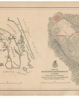
Map of the battlefield of Roanoke Id.
Full title
Map of the battlefield of Roanoke Id. Feb. 8th 1862
Date(s)
Created: 1862
Genre / form / medium
Medium(a): battlefield maps
Identifier(s)
http://hdl.loc.gov/loc.ndlpcoop/glva01.lva00204 | | | | | | |
Rights
Library of Congress, Geography and Map Division.
Rights
The content of the Library of Congress Geography and Map Division digitized collections are free to use and reuse unless stated otherwise.
Description
- The former indicates Union and Confederate troop positions, the location of a Confederate battery, a road bisecting the battlefield, and vegetation, while the latter shows forts and the number of guns at each, positions of Union and Confederate vessels, drainage, and names of principal features.
Detailed map of Roanoke Island battlefield and a map of Roanoke Island and vicinity.
Subject(s)
specifications
Parent Collection
Pages / children objects
Associated Media